International ocean observing system relocating to NC coast
This week, a team of scientists and engineers from Woods Hole Oceanographic Institution (WHOI) left Charleston, South Carolina, aboard the research vessel Neil Armstrong to begin test deployments in preparation for the installation of an observing system off the coast of North Carolina.
Researchers and scientific staff at East Carolina University’s Coastal Studies Institute (CSI) played an important role in choosing the new location for the Ocean Observatories Initiative (OOI) Pioneer Array, a network of platforms and sensors that will collect data.
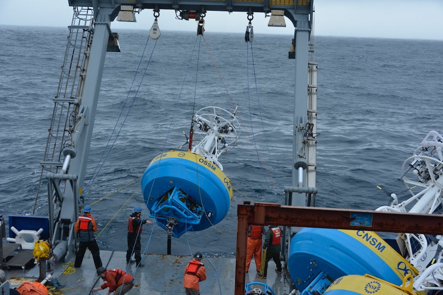
The team will deploy two test moorings occupying shallow and deep sites of the proposed array. The deployments will supplement computer modeling to ensure the mooring designs perform as expected in the mid-Atlantic bight (MAB) environment. Once the array is fully operational in 2024, the ocean data collected will be available online in near real time to anyone with an internet connection.
The information helps to track, predict, manage and adapt to changes in the marine environment. Coastal communities use ocean observing data to prepare for floods and other natural disasters. The instrumented arrays gather physical, chemical, geological and biological data from the air-sea interface to the seafloor, providing a wealth of information for research and education.
“The Coastal Studies Institute is excited about the observations that will be made from these instruments, allowing us to better address climate change influences in the coastal ocean, and improve ocean/weather/storm forecasts through data sharing,” said Reide Corbett, executive director of CSI. “Beyond just the instruments in the water, the new partnerships and collaborations created as part of this deployment will provide the ability to better engage this socio-economically diverse region, with disadvantaged groups more impacted by sea level rise and climate change compared to many coastal regions.”
The MAB location is expected to have different wind, wave and current conditions than the New England shelf, where Pioneer Array collected data from 2016-2022. In addition, deployments in the new location will be in both shallower and deeper water depths than those off the New England coast.
The OOI is funded by the National Science Foundation (NSF) to collect and deliver ocean data in select locations for 25 years or more. This longevity of data collection makes it possible for researchers to identify both short-term processes and long-term trends in the ocean. The NSF chose the location off the N.C. coast based on input from the science community during a series of 2022 workshops.
An update on the relocation by WHOI’s Dr. Al Plueddemann is planned for April 20 at 6 p.m. at the Coastal Studies Institute on ECU’s Outer Banks Campus as part of its “Science on the Sound” lecture series. The event is free and open to the public.
###
East Carolina University News Services
Howard House, 1001 E. Fifth Street
Greenville, NC 27858
ecunews@ecu.edu
Phone: 252-328-6481
news.ecu.edu
Contact: John McCord, associate director of outreach and education, Coastal Studies Institute, mccordr@ecu.edu, 252-475-5450
Provided photo
Photo by Darlene Trew Crist, Woods Hole Oceanographic Institution
The deployment team uses an A-frame at the stern of the ship to lift an OOI Coastal Surface Mooring into the water, with guidelines to ensure its movements are controlled.