PRECIPITATION PATTERNS
Project models regional weather systems
Professors and students in East Carolina University’s Department of Geography, Planning and Environment are taking an in-depth look at weather patterns in the southeastern United States, thanks to a $450,000 grant from the National Science Foundation.

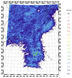
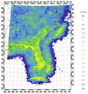
This graphic shows rainfall from isolated thunderstorms averaged over four years for the month of April. Precipitation patterns are dominated by widespread systems like cold fronts. (Contributed images)
There are two main types of rainfall in the region — widespread rain from large systems like fronts and tropical storms, and localized rain from isolated thunderstorms, said Dr. Rosana Ferreira, ECU associate professor of atmospheric science. Boaters and beachgoers, especially, are very familiar with the thunderstorms that pop up in the afternoon throughout the summer, and usually pass on within an hour or two.
“When you just look at precipitation without splitting it into these two components, it looks like it’s just flat year-round,” she said. “What we’ve found in our previous research is that buried in there is a ramping up of the thunderstorm season in the summertime, and then ramping back down, much like what you see in a monsoon climate.”
In the winter, when there is much less thunderstorm activity, there is more rain from the larger precipitation systems, resulting in a monthly rainfall total that’s relatively flat throughout the year.
Over the next three years, Ferreira and Dr. Tom Rickenbach, associate professor of atmospheric science, will be studying the springtime transition between those two dominant patterns in an effort to better understand and predict long-term regional precipitation.
“What we’re trying to understand is how the meteorological conditions, like the wind patterns and the amount of energy from heating of the atmosphere, are changing in the springtime as we ramp up toward the turning on of this afternoon thunderstorm regime,” Rickenbach said. “And we want to pinpoint the timing of that.”

In May, rainfall patterns begin to be dominated by smaller systems — isolated thunderstorms — that are mostly absent in the fall and winter.
The hypothesis is that the transition happens quickly, over perhaps a couple of weeks in late May and early June, as the jet stream shifts north and the North Atlantic subtropical high begins to feed warm, moist air into the southeastern states. The study will utilize a detailed radar dataset from the National Centers of Environmental Information, a repository of climate data.
“We have designed an algorithm that will … extract those smaller thunderstorm kinds of precipitation systems from the larger, widespread systems,” Rickenbach said.
One of the challenges is the sheer amount of data — terabytes of it.
“It’s a very large dataset, even by today’s standards,” said Ferreira.
The data will be averaged into five-day periods to determine when the transition occurs each year.
“And then we’ll find out what happened meteorologically just before that onset occurred and what happens afterward,” she said. “Where was the jet stream, where was the North Atlantic Subtropical High? And were there any fronts approaching or just passed? Was it a front that brought this on?”
Several graduate and undergraduate students will participate in the project, helping with the tracking of weather systems, modeling and analyzing data.
“They learn a lot about these various tools, and the management and analysis of the radar data. They learn a lot of programming as well,” Ferreira said.
“For our students, a project like this is a really important platform to gain experience and meet colleagues,” said Rickenbach. “We send them to at least one big meeting in the field, where they will present their work and potentially meet future employers or faculty at a program where they may pursue a Ph.D.”
Improving the understanding of these weather patterns and the mechanisms that drive them could improve long-term forecasting, with implications for things like agriculture and tourism.
“Climate models are a general circulation model over the entire planet,” said Ferreira. “By necessity it has to be … a broad picture. So it’s great for giving you an idea of what’s going to happen over large areas but not smaller regions.”
“That’s the hardest part of a climate model,” Rickenbach said. “I can’t tell the Carteret County manager, ‘In the next 15 years, here’s the way that our rain patterns will change.’ And they need that information.”
The project will also look at how regional precipitation could be affected by global changes like a warming climate. In the big picture, Rickenbach said, the earth is getting warmer. “But what’s more difficult to assess is how that general warming plays out with regional aspects of climate.”
“We’ll use a regional weather model to make simulations of what’s happening in the present climate,” Ferreira said, “and then repeat the simulations for the conditions we expect at the end of the century.”
Understanding the timing and mechanisms of the springtime transition between weather patterns will serve as a marker for comparison to see how the patterns might change as the climate changes. In the meantime, the study will provide unique educational opportunities for ECU students and potential benefits for the entire region.

Dr. Rosana Ferreira and Dr. Tom Rickenbach (Photo by Cliff Hollis)
