ECU scientists part of international New Zealand ocean research expedition

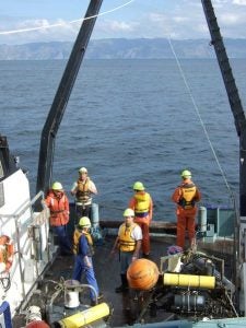
Dr. J.P. Walsh, professor in the ECU Department of Geological Sciences, (foreground) and crew examine instruments recovered from the seafloor aboard R/V Kaharoa in May during a research trip to New Zealand.
GREENVILLE, NC — Two East Carolina University professors are among an international team of scientists working to understand sedimentation patterns and their effects on oceans.
The research focuses on how materials from land are moved through and accumulated in the ocean and in particular how floods carry sediments along the coast.
“This knowledge may be valuable to understanding how pollutants like oil are dispersed or buried in the seafloor,” said Dr. J.P. Walsh, professor in the ECU Department of Geological Sciences.
“Also because our historical records of storms are limited, sedimentary strata created in the ocean can provide key insights into how such events have varied over time, perhaps in response to climate change,” he said.
Walsh, also of ECU’s Institute of Coastal Science and Policy, was the chief scientist on a late-May expedition to New Zealand’s Waipaoa River to gather study data. Collaborating on the expedition was Dr. Reide Corbett, associate professor of geological sciences and also with the Institute of Coastal Science and Policy.
Corbett said, “This research gives us an opportunity to evaluate how the geologic record is emplaced in near real-time. This work will ultimately provide scientist a better foundation to interpret environmental and climatic changes that have occurred over a range of timescales.”
Researchers from ECU, the University of Washington and the Virginia Institute of Marine Science are working closely with Dr. Alan Orpin of New Zealand’s National Institute for Water and Atmospheric Research in the study.
The study is examining how eroded materials, caused by high rainfall, are transported and deposited in the adjacent energetic sea. The Waipaoa River, which drains the East Cape region of the New Zealand’s North Island, is the focus because it is small yet discharges a large amount of sediment, which enables scientists to more easily access and measure the system.
Scientists took samples of the seafloor and deployed sensors in January. Soon after, rain pounded steep hills and valleys of New Zealand’s east coast, causing washed-out roads, high river levels, flooding, and evacuations.
The rain resulted from an unusual low-pressure system that moved over the country’s North Island. Such flooding can occur about every eight years, according to statistical estimates.
Infrequent, but large, flooding is important because it can cause significant erosion. Offshore sediment layers resulting from these events may give clues about the frequency and magnitude of such extreme climatic conditions, which may have been less common in the past. To find such clues, scientists must determine how layers are emplaced as well as how such layers may be modified by subsequent ocean events such as storm waves.
After the flooding in January, a small team led by Dr. Tara Kniskern of the Virginia Institute of Marine Science extracted seabed samples and identified flood deposits. In May, scientists got more samples and retrieved and redeployed ocean sensors. Two more sampling trips are planned over the next year.
The scientific team has already collected a lot of informative data. X-Ray images reveal ocean sediments in some places are composed of numerous layers, suggesting floods and storm waves and have produced a complex record of sedimentation.
These data and other information gathered will be used to decipher the character is the recent flood layers, as well as historical events.
“Ultimately, this work will give valuable insight into the many storms that have impacted this region and also will provide a model for understanding other areas around the world,” Walsh said.
The research is supported by a grant from the National Science Foundation and with personnel and logistical assistance from New Zealand’s National Institute.
Members of the research team are pursuing grant support to help understand oil dispersal by sediments of the Gulf of Mexico.

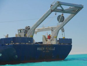
Dr. Reide Corbett, associate professor in the ECU Department of Geological Sciences, center, directs coring operations from the R/V Revelle in January during a research trip to New Zealand.